The final leg on my short (in time, if not in distance - 2400km in all) Balkans tour was to take me from the bridge crossing at Ruse in Bulgaria into Romania and thence to cross back over the Danube into Serbia at Drobeta Turnu Severin. I had intended to visit the BGRORS tripoint marker on the Romanian bank of the Danube on the way but the lateness of the hour, a traffic jam on the Bucharest ring road and the early sunset in November sadly precluded that. Maybe another day.
When I got to Drobeta-Turnu Severin I was perplexed because I didn't realise just how far north of the town the bridge across the Danube lay. This is not really a bridge actually - really it is a dam. Anyway, I had seen no signs to "Serbia" and so had started to make plans to drive further north in Romania when suddenly the crossing appeared. It was so poorly marked that, in the dark and the rain, I missed the turning, went past it, and had to turn around to find the entrance. All this despite having Garmin GPS maps of both countries on my laptop connected to a GPS - but the crossing was not shown on either of them!!
The following video shows my journey across the river - this was not the best quality as the autofocus kept thinking it should focus on the raindrops on my windscreen rather than the outside objects - and the rain and dark made it not especially clear - but it is the best I could do.
After that it was simply a matter of driving about 2½ more hours to Belgrade, finding my hotel, and checking in to relax before flying to London the next day.
So that is the end of my short Balkans tour - There are just 4 more countries in the region for me to visit (Bosnia and Herzegovina, Montenegro, Albania and Macedonia-FYROM), or 5 if you include Kosovo (which I shall eschew for a while until things are a bit safer there - plus I don't want to get into the politics of whether it really is a county or not either). Additionally, once I have visited those, Moldova and Monaco I shall have set foot in every European country on the continental mainland. (I'm choosing not to count Armenia, Azerbaijan, Georgia and Kazakhstan as "Europe" despite their transcontinental nature if you have a certain opinion of where the border of Europe lies).
This tour took me to 2 new countries for me - 5 new borders - and added 5 more countries to my list of where I have found geocaches (bringing that total to 42).
Still lots more borders to cross and areas to spend more time investigating - so more blogging WILL follow for my subsequent trips.
Friday, 14 November 2008


Friday, 7 November 2008
The Balkans - 5 - Bulgaria to Romania
Crossing the Danube from Bulgaria to Romania needs a ferry if you are going to do it anywhere west of Rousse (variously spelled Ruse, Russe according to roadsigns I witnessed on the way there - it is, after all, consistently spelled Pyce in the Cyrillic alphabet so the Roman alphabet spellings are simply phonetic). So I chose to take the bridge as you can see in the video below. This brings you out south of Bucharest.
It was a fairly uneventful crossing and went very quickly, which was a welcome change after my experiences in Turkey, especially as I had a long drive ahead of me to Belgrade.
It was a fairly uneventful crossing and went very quickly, which was a welcome change after my experiences in Turkey, especially as I had a long drive ahead of me to Belgrade.
Thursday, 6 November 2008
The Balkans - 4 - Turkey to Bulgaria
Distances are longer than they seem on the map sometimes. After my visit to Gallipolli I drove to the Turkey Bulgaria border just west of Edirne in Turkey. This involved a short distance of toll road and I had no Turkish money and they didn't take credit cards. This presented a small problem but the toll collector indicated I could pay him one Euro. However I only had 50 Euro notes in that currency so it looked like I was going to have a problem. But then he said "One Dollar" - and having some US dollars in my wallet I was through (saving some expense compared to the Euro price in the bargain).
It was dark when I reached the border and for some reason I did not run the camera as I went through so there is no video - sorry. I had originally intended to see if I could arrange to visit the BGGRTR tripoint but my e-mail to the Turkish officials had gone unanswered and it was very late and dark anyway so I had to forego that pleasure.
The Turkish side of the border crossing is undergoing major construction work and is pretty chaotic, with few signs to indicate just where you should go and many unpaved roads, uncompleted buildings and so on.
The final check on the Turkish side was to examine the vehicle's papers and there was a (mercifully short) line there - but, even so, each car took about 4 to 5 minutes to be processed and that meant it took me over an hour to get through even this short line. It seems amazing that there was only one person checking these papers.
Once across the bridge into Bulgaria I had a repeat of the process I went through crossing from Serbia (with the "chip" and so on).
Then it was off to Romania and the last couple of legs of my tour.
It was dark when I reached the border and for some reason I did not run the camera as I went through so there is no video - sorry. I had originally intended to see if I could arrange to visit the BGGRTR tripoint but my e-mail to the Turkish officials had gone unanswered and it was very late and dark anyway so I had to forego that pleasure.
The Turkish side of the border crossing is undergoing major construction work and is pretty chaotic, with few signs to indicate just where you should go and many unpaved roads, uncompleted buildings and so on.
The final check on the Turkish side was to examine the vehicle's papers and there was a (mercifully short) line there - but, even so, each car took about 4 to 5 minutes to be processed and that meant it took me over an hour to get through even this short line. It seems amazing that there was only one person checking these papers.
Once across the bridge into Bulgaria I had a repeat of the process I went through crossing from Serbia (with the "chip" and so on).
Then it was off to Romania and the last couple of legs of my tour.
The Balkans - 3 - Greece to Turkey
Having crossed from Bulgaria into Greece I drove down the eastern border of Greece to the crossing into Turkey near Ipsala, Turkey.
First of all, however, I made a small detour near the Bulgaria/Turkey/Greece tripiont into the Greek village of Kastanies which has a border crossing with Turkey. I think this is the only land (as in not even across a river) border crossing between the two countries. I did not want to enter Turkey at this point as I had a mission to find a geocache in Greece first - but I did check out the border post on the Greek side as you can see in the following video.
The actual crossing into Turkey, however, was another story. As you can see from the following video, the Greek authorities were concerned about my camera as well as the documents for the car. The car being registered in Serbia, and being a rental, they wanted to check that it was permitted to take it into Turkey before they would let me through. Although the insurance documents were in order there was no annotation in the rental contract about taking it into any other country. Fortunately I eventually remembered that I had a paper copy of the original booking off the internet and that explicitly stated that I was allowed to take the car into both Greece and Turkey and that satisfied them. As for my camera, they wanted to check that I had not taken any video of "prohibited" places in Greece (although how I was supposed to know that an particular place was "prohibited" I don't know). They spent some time looking at the video footage I had taken and eventually seemed content to let me proceed, asking me not to video the area between the inspection post and the border. You can see the result in the video below. For a fuller video of the actual border crossing I have found this one on YouTube which may be of interest.
Once I reached the Turkish side it was a matter of a lot of stops, my failure to understand the instructions being given in virtually non-existent English about where to go to buy a tourist visa, all of which combined with the delays on the Greek side to make this border crossing take about 2 hours. Sadly this meant that I arrived at the Anzac memorial to Gallipolli just after sunset (1715 at this time of year) which lessed the impact of that most interesting place.
First of all, however, I made a small detour near the Bulgaria/Turkey/Greece tripiont into the Greek village of Kastanies which has a border crossing with Turkey. I think this is the only land (as in not even across a river) border crossing between the two countries. I did not want to enter Turkey at this point as I had a mission to find a geocache in Greece first - but I did check out the border post on the Greek side as you can see in the following video.
The actual crossing into Turkey, however, was another story. As you can see from the following video, the Greek authorities were concerned about my camera as well as the documents for the car. The car being registered in Serbia, and being a rental, they wanted to check that it was permitted to take it into Turkey before they would let me through. Although the insurance documents were in order there was no annotation in the rental contract about taking it into any other country. Fortunately I eventually remembered that I had a paper copy of the original booking off the internet and that explicitly stated that I was allowed to take the car into both Greece and Turkey and that satisfied them. As for my camera, they wanted to check that I had not taken any video of "prohibited" places in Greece (although how I was supposed to know that an particular place was "prohibited" I don't know). They spent some time looking at the video footage I had taken and eventually seemed content to let me proceed, asking me not to video the area between the inspection post and the border. You can see the result in the video below. For a fuller video of the actual border crossing I have found this one on YouTube which may be of interest.
Once I reached the Turkish side it was a matter of a lot of stops, my failure to understand the instructions being given in virtually non-existent English about where to go to buy a tourist visa, all of which combined with the delays on the Greek side to make this border crossing take about 2 hours. Sadly this meant that I arrived at the Anzac memorial to Gallipolli just after sunset (1715 at this time of year) which lessed the impact of that most interesting place.
The Balkans - 2 - Bulgaria to Greece
Stage 2 on my Balkans tour was to cross the Bulgaria-Greece border at its eastern end by driving along the E85 between the two countries. This was fairly straightforward and I did not even have to show my passport at the Greek border as can be seen from the following video
Wednesday, 5 November 2008
The Balkans - 1 - Serbia to Bulgaria
Before some meetings in London next week I have the opportunity to visit the Balkans for a couple of days. I planned my visit so that I could cross as many borders, visit as many (new for me) countries, and find as many geocaches in as many (new for me) countries as possible. The main region of Europe that I have never visited lay in the southeast, the Balkans.
While planning my trip one consideration was to find somewhere that I could rent a car that I would be allowed to drive into other countries. At first I had considered flying to Bucharest but rentals from Romania cannot be driven into the former Yugoslavia or (I think) Turkey. Rentals from Bulgaria or Greece could not be driven into any other country. However rentals from Serbia and Macedonia were less restrictive. Macedonian rentals could not be driven to Bulgaria or Turkey but could go to Greece, Albania and the rest of the former Yugoslavia. Rentals from Serbia could not be driven to Macedonia or Albania but could go to Bulgaria and (it appeared) to Turkey. So I elected to fly to Belgrade and start my adventure from there.
Because of the time differences and flight schedules it was going to be a tight timeline - my flight would not arrive in Belgrade until 15:50 having left Canada the night before (changing in Frankfurt) and sunset was shortly after 16:00. I planned to drive to Sofia, Bulgaria on arrival and the border crossing would also take me into another timezone where I would lose yet another hour. Naturally Lufthansa managed to lose my suitcase which then meant that I was further delayed by almost 2 hours at Belgrade airport sorting that out - and they would not deliver the case outside Serbia so I had to arrange for them to deliver it to the hotel in Belgrade that I would be staying in on my eventual return there. I had to live without it for a couple of days. Fortunately I always pack the essentials in my carry-on including all my navigation equipment (computers, GPS etc.) so my only discomfort was not having a change of clothes and not having the nice computer stand that I could install in the rental car to make the navigation computer more accessible (I therefore had to operate it as it sat on the passenger seat).
Driving to Bulgaria is mostly Motorway - the following two videos were shot from my dash mounted camera as I went through the various checkpoints at the border.
I found it fairly confusing at first figuring out whether I had left Serbia or not - some borders have the check points from both countries together and I had thought that might have been the case here - you will notice my confusion on the video.
Then the process of entering Bulgaria was interesting. There were numerous stops - customs, passport control, purchase local currency, vehicle document checking, purchase vignette to allow driving on the main Bulgarian roads and finally payment of all necessary charges. To follow you through all this they give you a USB stick at the first checkpoint that is referred to as a "chip" at each subsequent one and you are expected to hand this to the agent at each of the points as you go through for them to update. I was very tempted to pop it into my computer, which was on the seat beside me running my GPS, to see what was on it. However, by the time I had thought of doing so it was too late and I was at the final check point.
So, here are the videos:
Part 1 (9 min 52 secs)
Part 2 (5 min 14 secs)
While planning my trip one consideration was to find somewhere that I could rent a car that I would be allowed to drive into other countries. At first I had considered flying to Bucharest but rentals from Romania cannot be driven into the former Yugoslavia or (I think) Turkey. Rentals from Bulgaria or Greece could not be driven into any other country. However rentals from Serbia and Macedonia were less restrictive. Macedonian rentals could not be driven to Bulgaria or Turkey but could go to Greece, Albania and the rest of the former Yugoslavia. Rentals from Serbia could not be driven to Macedonia or Albania but could go to Bulgaria and (it appeared) to Turkey. So I elected to fly to Belgrade and start my adventure from there.
Because of the time differences and flight schedules it was going to be a tight timeline - my flight would not arrive in Belgrade until 15:50 having left Canada the night before (changing in Frankfurt) and sunset was shortly after 16:00. I planned to drive to Sofia, Bulgaria on arrival and the border crossing would also take me into another timezone where I would lose yet another hour. Naturally Lufthansa managed to lose my suitcase which then meant that I was further delayed by almost 2 hours at Belgrade airport sorting that out - and they would not deliver the case outside Serbia so I had to arrange for them to deliver it to the hotel in Belgrade that I would be staying in on my eventual return there. I had to live without it for a couple of days. Fortunately I always pack the essentials in my carry-on including all my navigation equipment (computers, GPS etc.) so my only discomfort was not having a change of clothes and not having the nice computer stand that I could install in the rental car to make the navigation computer more accessible (I therefore had to operate it as it sat on the passenger seat).
Driving to Bulgaria is mostly Motorway - the following two videos were shot from my dash mounted camera as I went through the various checkpoints at the border.
I found it fairly confusing at first figuring out whether I had left Serbia or not - some borders have the check points from both countries together and I had thought that might have been the case here - you will notice my confusion on the video.
Then the process of entering Bulgaria was interesting. There were numerous stops - customs, passport control, purchase local currency, vehicle document checking, purchase vignette to allow driving on the main Bulgarian roads and finally payment of all necessary charges. To follow you through all this they give you a USB stick at the first checkpoint that is referred to as a "chip" at each subsequent one and you are expected to hand this to the agent at each of the points as you go through for them to update. I was very tempted to pop it into my computer, which was on the seat beside me running my GPS, to see what was on it. However, by the time I had thought of doing so it was too late and I was at the final check point.
So, here are the videos:
Part 1 (9 min 52 secs)
Part 2 (5 min 14 secs)
Friday, 15 August 2008
Suderwick - Dinxperlo
A short visit to the Dutch-German Border divided town of Dinxperlo/Suderwick. Here is a brief video (in 2 parts because of the YouTube limitation to 10 minutes per video) of my drive through this town - not as large as Kerkrade-Herzogenrath but similar in that the border runs down the middle of the street. I was alerted to this place by someone who had viewed my Kerkrade-Herzogenrath video on YouTube.
Suderwick/Dinxperlo are situated as shown in the map below:

The video starts at point 1 in the map below, proceeds to point 2 where I turn around and drive to point 3, where I turn around again and return to point 1.

Part 1 (5 min 50 sec)
Part 2 (6 min 37 sec)
Suderwick/Dinxperlo are situated as shown in the map below:

The video starts at point 1 in the map below, proceeds to point 2 where I turn around and drive to point 3, where I turn around again and return to point 1.

Part 1 (5 min 50 sec)
Part 2 (6 min 37 sec)
Saturday, 10 May 2008
BEFRLU
Heading back to Brussels after staying the night in Luxembourg I first explored a rather interesting open mining area that had been turned back into a nature reserve and then went to explore the BEFRLU tripoint. There is apparently a new border marker on the LU side. This is a rather ugly place compared with the beauty of the BEDELU spot. The following 2 videos include my approach, visiting the tripoint itself, and driving completely around it. Being a wet tripoint it is not practical to do the 3 country run so I thought this was the next best thing.
Here first is the Google map of the area.
View Larger Map
The first video starts with me coming from LU along the E44 (LU 5), turning north onto the 51 which becomes the 804 on entering BE. I go round the roundabout and back to the tripoint.
The higher quality version is on YouTube
On leaving the tripoint I go south on the 51, east on the E44, enter FR and then turn north onto the N18, up to the roundabout and then east onto the d46b back to the earlier roundabout which again I go right around and exit back westwards.
The higher quality version is on YouTube
This is the last entry in my blog for this trip.
Here first is the Google map of the area.
View Larger Map
The first video starts with me coming from LU along the E44 (LU 5), turning north onto the 51 which becomes the 804 on entering BE. I go round the roundabout and back to the tripoint.
The higher quality version is on YouTube
On leaving the tripoint I go south on the 51, east on the E44, enter FR and then turn north onto the N18, up to the roundabout and then east onto the d46b back to the earlier roundabout which again I go right around and exit back westwards.
The higher quality version is on YouTube
This is the last entry in my blog for this trip.
Friday, 9 May 2008
Luxembourg
Northernmost point in Luxembourg and on to the Lancaster Memorial.
Here is a google map of the northernmost point.
View Larger Map
And of the Lancaster Memorial:
View Larger Map
For a higher quality version see the YouTube page hosting this video
Next, on to the BEDELU tripoint/tri-line
For a higher quality version see the YouTube page hosting this video
Here is a google map of the northernmost point.
View Larger Map
And of the Lancaster Memorial:
View Larger Map
For a higher quality version see the YouTube page hosting this video
Next, on to the BEDELU tripoint/tri-line
For a higher quality version see the YouTube page hosting this video
Vennbahn - L106 to Mützenich to Kalterherberg, Ruitzhof Enclave
Leaving the Aderich area I drove along the L106 through Mützenich to Kalterherberg and then into the Ruitzhof enclave. I have had to divide this video into two because of the YouTube 10 minute time limit.
Part One (Hosted at You Tube Here):
Part Two (Hosted at YouTube here):
Unfortunately one feature of my camera that I had not realised about is the "drop protection" that turns it off when it thinks it is being dropped. Because it writes the video image directly to a hard drive, this is to protect the disk. When I started to drive over the rough track at the end of the Ruitzhof enclave, the bouncing made it think it was being dropped and so it turned itself off. Sadly I didn't notice this until a long time afterwards so there was no video of the return journey recorded.
Part One (Hosted at You Tube Here):
Part Two (Hosted at YouTube here):
Unfortunately one feature of my camera that I had not realised about is the "drop protection" that turns it off when it thinks it is being dropped. Because it writes the video image directly to a hard drive, this is to protect the disk. When I started to drive over the rough track at the end of the Ruitzhof enclave, the bouncing made it think it was being dropped and so it turned itself off. Sadly I didn't notice this until a long time afterwards so there was no video of the return journey recorded.
Aderich and the L106
Next I drove past the "German Farm" (Rückschlag), through Aderich and took the opportunity to take a much closer look at the L106 where it goes through Belgium - marked on the maps here as "Where is the border?"
German map:

Belgian map:

It was interesting to notice that the roadside markers in the section of road that appears to run through Belgium were identical (German) design to those clearly in Germany, but the distances marked on them appeared to be measured from where the border crosses the road, as shown on the German map above.
Here is the video of my drive through this area.
To see this in higher resolution visit the YouTube page where it is hosted.
German map:

Belgian map:

It was interesting to notice that the roadside markers in the section of road that appears to run through Belgium were identical (German) design to those clearly in Germany, but the distances marked on them appeared to be measured from where the border crosses the road, as shown on the German map above.
Here is the video of my drive through this area.
To see this in higher resolution visit the YouTube page where it is hosted.
B258-Fringshaus-Konzen
After leaving Roetgen I dorve down the B258 towards Konzen, stopping at the side of the road (in Germany) briefly to find a geocache a few meters into the woods on the right hand side (in Belgium - the border runs alonside the road here). This video starts from where I had stopped, takes you past the Fringshaus, along the "German road in Belgium" and (after missing the turn and having to turn around) ends at the turn off for Aderich (where the "German Farm" - Rückschlag is).
To see this in higher resolution visit the YouTube page where it is hosted.
To see this in higher resolution visit the YouTube page where it is hosted.
Vennbahn - Roetgen Station
Last time I visited the Belgian/Gernam border area I spent quite a lot of time investigating the Vennbahn but I failed to stop at Roetgen Station. The borders around here are particularly confusing so on this trip I took the opportunity to wander around a bit and record some video of the area.
The station is just north of Mühlenstraße on the map below (reproduced from the blog of my previous visit)

The exact border lines on the road are not clear at all but some of the signs on the buildings give some idea of where they might lie.
To see this video in better quality visit the YouTube page where it is hosted.
The station is just north of Mühlenstraße on the map below (reproduced from the blog of my previous visit)

The exact border lines on the road are not clear at all but some of the signs on the buildings give some idea of where they might lie.
To see this video in better quality visit the YouTube page where it is hosted.
Aachen-Vaals-BEDENL
Following my investigation of Kerkrade-Herzogenrath I drove a short way south to where the German town of Aachen and the Dutch town of Vaals meet at the international border. After finding a geocache (Westwall Bunkercache "MG-Schild Wachtelkopf") near an old German bunker which was right across the road from the DENL border (just north of Vaals, on Senserbachweg), I drove through the outskirts of Aachen and the town of Vaals and then on to the BEDENL tripoint. Here is some video of parts of that trip.
Again, I hope this gives you a bit of a flavour of this part of my trip.
To see this in higher resolution you will need to visit the YouTube page where it is hosted.
Next stop - a few places on the Vennbahn and the BEDE border area as I head south towards Luxembourg.
Again, I hope this gives you a bit of a flavour of this part of my trip.
To see this in higher resolution you will need to visit the YouTube page where it is hosted.
Next stop - a few places on the Vennbahn and the BEDE border area as I head south towards Luxembourg.
Kerkrade-Herzogenrath Revisited
After my conference in Eindhoven, Netherlands was over I decided to revisit a few border places I had been before, as well as a few new ones, on my drive to Luxembourg. Since my previous visit to the region I had acquired a dashboard mount for my video camera (called a Sticky Pod) and this was my first chance to try it out "in the field". I decided to drive up and down the divided road in these two towns, taking video as I went, and providing some commentary as well. I hope that this will provide an even better idea of the place than I was able to with just still photos from my previous trip
If you want to see this in higher quality you will have to go to where it is hosted on the YouTube site
Peter Smaardijk has kindly provided me a couple of links that address some of the questions I raise in the video about what this street used to look like. (For copyright reasons the images displayed here are displayed from the website on which they resided when this log entry was created, i.e. they have not been copied. If they are removed from that website they will not appear here properly).
First the Gemeente Kerkrade page has the following 3 pictures on it:
Here is the pre 1968 situation with barbed wire:

After 1968 there was just a low concrete barrier defining the border.

And, of course, today the road zigs and zags back and forth across the border.

Secondly the http://www.grenzen.150m.com/ site has the following picture which shows the remainder of the concrete barrier as a "monument" in the centre of a roundabout. This is visible at 2:22 and 7:43 of my video.

If you want to see this in higher quality you will have to go to where it is hosted on the YouTube site
Peter Smaardijk has kindly provided me a couple of links that address some of the questions I raise in the video about what this street used to look like. (For copyright reasons the images displayed here are displayed from the website on which they resided when this log entry was created, i.e. they have not been copied. If they are removed from that website they will not appear here properly).
First the Gemeente Kerkrade page has the following 3 pictures on it:
Here is the pre 1968 situation with barbed wire:

After 1968 there was just a low concrete barrier defining the border.

And, of course, today the road zigs and zags back and forth across the border.

Secondly the http://www.grenzen.150m.com/ site has the following picture which shows the remainder of the concrete barrier as a "monument" in the centre of a roundabout. This is visible at 2:22 and 7:43 of my video.

Thursday, 8 May 2008
Baarle
A nice sunny evening and a colleague and I took a trip from Eindhoven, where we were at a conference, to visit the two towns of Baarle-Nassau (Netherlands) and Baarle-Hertog (Belgium). While we didn't see all the border attractions in the town we did manage to walk around and spot a few interesting places that I captured on the video below.
To help you navigate around I have included captions for the different streets and here is a local map showing Belgium in yellow and the Netherlands in white. You can click on it for the full size image (about 2MB).

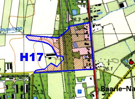
The enclave to the south of town that we visited was H17 - here is a map from the wonderful website http://www.grenspalen.nl/archief/index.html, where you will also find lots of other interesting information about Baarle and other Dutch borders. The road we drove down, and where the video is taken from, is the small yellow one that passes through the west side of the enclave (twice), not the red one that forms the eastern border of the enclave. The video is taken from the northenmost border crossing point on that road.

As we were driving south to here from the main part of the town we were passed by two police vehicles with flashing lights, going north. Dutch police in the lead, Belgian police right behind. This got me to wondering about the complexities of policing in this area - I suspect that you typically need to have both police forces operating together to ensure there is appropriate jurisdiction. The idea of the police from one country driving through another country as part of their duty is interesting to say the least.
The video also includes a segment at the end as we drive back to Eindhoven and cross the border from Belgium back to the Netherlands on the main E34 motorway.
To see this video in higher resolution you will need to visit the YouTube page where it resides.
I hope this helps to give an idea of this place and that you found it interesting. Please leave comments to help me improve my trip reports for future trips.
To help you navigate around I have included captions for the different streets and here is a local map showing Belgium in yellow and the Netherlands in white. You can click on it for the full size image (about 2MB).

The enclave to the south of town that we visited was H17 - here is a map from the wonderful website http://www.grenspalen.nl/archief/index.html, where you will also find lots of other interesting information about Baarle and other Dutch borders. The road we drove down, and where the video is taken from, is the small yellow one that passes through the west side of the enclave (twice), not the red one that forms the eastern border of the enclave. The video is taken from the northenmost border crossing point on that road.
As we were driving south to here from the main part of the town we were passed by two police vehicles with flashing lights, going north. Dutch police in the lead, Belgian police right behind. This got me to wondering about the complexities of policing in this area - I suspect that you typically need to have both police forces operating together to ensure there is appropriate jurisdiction. The idea of the police from one country driving through another country as part of their duty is interesting to say the least.
The video also includes a segment at the end as we drive back to Eindhoven and cross the border from Belgium back to the Netherlands on the main E34 motorway.
To see this video in higher resolution you will need to visit the YouTube page where it resides.
I hope this helps to give an idea of this place and that you found it interesting. Please leave comments to help me improve my trip reports for future trips.
Saturday, 29 September 2007
The Southernmost Point of the Asian Continent
As part of a short day trip to Singapore from Kuala Lumpur I visited a location that calls itself "The Southernmost Point of the Asian Continent". This is on Sentosa Island in Singapore but actually I think it is not exactly at the very southernmost part of Sentosa. You might ask, "How can an island contain the southermost part of the Continent?". Well it makes this claim because it is connected to Malaysia via bridges from Sentosa to Singapore proper and thence to Malaysia - so you could walk from here to the continent proper.
It is only about 139km north of the Equator - being at latitude N 1° 14' approximately.
Here are a few photos from this place.


And a video of the area:
It is only about 139km north of the Equator - being at latitude N 1° 14' approximately.
Here are a few photos from this place.


And a video of the area:
Friday, 6 July 2007
Kerkrade-Herzogenrath
My last set of border photos for the day are from the towns of Kerkrade (Netherlands) and Herzogenrath (Germany), where the border runs up the middle of one of the streets - quite innocuously with no significant sign that there is a border here. At the end of my trip I encountered a very pleasant and interesting surprise that I had not expected.
Read on.
First the obligatory map - the red line shows the border and the places where I took some photos are marked as 1 and 2. It was getting quite late now and I still had to get on to Düsseldorf for an early flight to London the next morning so I didn't stop to take photos in between these two spots.

This photo is looking north along the divided road, Netherlands on the left, Germany on the right. It seems to have changed somewhat from previous photos I had seen of the area - something I was to feel as I failed to recognise much of where I then drove.

This video starts looking West North West, pretty much along the border line. I'm not sure if the houses to the left (south) of the street would be in the Netherlands or Germany.
Some more views of the area - note the white and blue street signs in Dutch and German.


I then drove to point 2 which is where the border leaves the centre of the road. I noticed that the road had been significantly changed from previous photos that I had seen with "traffic calming" islands placed along the sides of the road alternating from the Dutch to the German side thereby causing traffic along the street to constantly zig-zag back and forth between the Netherlands and Germany - true multinationalism at work here.
I was using an older German map rather than the Dutch map I have provided here, and this did not have the roundabout we see here marked on it. So, needless to say, this was a huge surprise for me - and what was the other side of the roundabout was an even bigger, and most pleasant, surprise.

Beyond the roundabout is the Eurode Centre - an office complex that straddles the border. I drove (anti-clockwise) around the building and noticed the border signs as I re-entered the Netherlands at the back of the building. So, where the bi-national road had previously petered out somewhat ignominiously, the opportunity had been taken to construct a most imaginative complex that enables companies to take advantage of the border line in many ways.

This is the front entrance - the border runs between the two doors - there is a Dutch mailbox on the left and a German one on the right.

I took a few more photos of the area - I am standing here on the northwest corner of the roundabout looking south.

German sign as the road heads off to the north east

On the Dutch side of the road the Dutch name is on the top:

and on the German side of the road, the German name is on the top.

OK - that was pretty much it. I still wanted to find one geocache in the Netherlands - and there was one in Kerkrade fortunately (albeit a rather lame micro) and to drive along the former N274 Dutch road that crosses a small bit of Germany and used to be completely separated from the German road system. I did so - there are now roundabouts joining it to the German road system since it reverted to German control in 2002 - but it was now getting really late so no photos. Then I headed off to my hotel in Düsseldorf enjoying the empty A46 where I was able legally to hit over 200km/h in places.
Read on.
First the obligatory map - the red line shows the border and the places where I took some photos are marked as 1 and 2. It was getting quite late now and I still had to get on to Düsseldorf for an early flight to London the next morning so I didn't stop to take photos in between these two spots.

This photo is looking north along the divided road, Netherlands on the left, Germany on the right. It seems to have changed somewhat from previous photos I had seen of the area - something I was to feel as I failed to recognise much of where I then drove.

This video starts looking West North West, pretty much along the border line. I'm not sure if the houses to the left (south) of the street would be in the Netherlands or Germany.
Some more views of the area - note the white and blue street signs in Dutch and German.


I then drove to point 2 which is where the border leaves the centre of the road. I noticed that the road had been significantly changed from previous photos that I had seen with "traffic calming" islands placed along the sides of the road alternating from the Dutch to the German side thereby causing traffic along the street to constantly zig-zag back and forth between the Netherlands and Germany - true multinationalism at work here.
I was using an older German map rather than the Dutch map I have provided here, and this did not have the roundabout we see here marked on it. So, needless to say, this was a huge surprise for me - and what was the other side of the roundabout was an even bigger, and most pleasant, surprise.

Beyond the roundabout is the Eurode Centre - an office complex that straddles the border. I drove (anti-clockwise) around the building and noticed the border signs as I re-entered the Netherlands at the back of the building. So, where the bi-national road had previously petered out somewhat ignominiously, the opportunity had been taken to construct a most imaginative complex that enables companies to take advantage of the border line in many ways.

This is the front entrance - the border runs between the two doors - there is a Dutch mailbox on the left and a German one on the right.

I took a few more photos of the area - I am standing here on the northwest corner of the roundabout looking south.

German sign as the road heads off to the north east

On the Dutch side of the road the Dutch name is on the top:

and on the German side of the road, the German name is on the top.

OK - that was pretty much it. I still wanted to find one geocache in the Netherlands - and there was one in Kerkrade fortunately (albeit a rather lame micro) and to drive along the former N274 Dutch road that crosses a small bit of Germany and used to be completely separated from the German road system. I did so - there are now roundabouts joining it to the German road system since it reverted to German control in 2002 - but it was now getting really late so no photos. Then I headed off to my hotel in Düsseldorf enjoying the empty A46 where I was able legally to hit over 200km/h in places.
Neutral Moresnet - and some older Burgundian borders
Now it was time to visit the former Neutral Moresnet and seek out some border markers. My original plan included only the border markers of Neutral Moresnet itself, however I found myself also investigating a few older border markers that date back to the Burgundian/Prussian days.
First a map with the numbers indicating various key spots on my tour. The blue and red lines roughly mark the route that I walked while exploring the hinterland (blue outbound, red inbound) following the well thought out directions provided by the creator of this geocache.
 Before we start you might like to take a look at this excellent website about the bordermarkers of Neutral Moresnet - following various links from there will take you to all sorts of other interesting places too :) - but do come back here please...
As I drove down the hill from the BEDENL tripoint I stopped to try and find my first Neutral Moresnet border marker around point number 1 on my map above. The map indicated that it should be fairly close to the road. I was not successful, however I did find the following:
This appears to be an old Burgundian marker - something that I did not realise until later in my expedition when I found some others and thus recognised the style.
The side with the writing:

the back side:

also in the area was another marker (and again I found other similar ones later on) but it had no visible inscriptions and so I am still puzzled as to what it is actually signifying. You can see the marker from the pictures above in the background of the picture, which I took deliberately so as to show both of these markers in relation to each other.

a close up shot - perhaps someone can make out a man made pattern here that indicates something?

Anyway, my main goal today was to visit a few markers that had been used as key points for a geocache called Klenkes 2005 - Grenzsteine - this was a multi that required about a 6.5 km walk around the Neutral Moresnet hinterland and so I decided to use it as my guide for the day.
I parked my car at the point marked number 2 on my map and proceeded to cross the territory towards point number 3. As I approached point number 3 I took this video of the surroundings. By the way - I would be really grateful if someone could let me know if I have pronounced Moresnet correctly - I assumed that the French pronunciation (silent "t" for example) would not be correct but it would be nice to hear from SWK ("someone who knows") - thanks.
Moving north up the trail from point number 3 I encountered my first border marker, number 51 (marked in Roman numerals - LI). Sadly some moron had defaced it - this was not the first time I would see this type of thing regrettably.


Proceeding further north I passed spots where the map indicated there should be other border markers, however they were not immediately evident and I didn't have time or energy to go scrabbling through the undergrowth to look for them. I will leave that for another day, and hopefully can find someone who has exact GPS coordinates for them to make the search easier.
This photo is looking north along the border at point number 4 on my map. The geocache instructions said to follow the path as it forks to the left here - upon some investigation I discovered not only that this was an easier path, but also that there was a notice (obscured by the first bush just to the right of the track in this photo) indicating that no foot traffic was permitted along the border track. Should anyone have challenged me I could have claimed that I had not seen it since it was so well obscured, however, I knew the whole walk would be long enough, and it was already 1715, that I decided to opt for the easier route.

The next marker I found was number 44. This exemplifies really well the unusual style of Roman numerals used. Whereas it would be more common to denote this LXIV, instead the (older) XXXXIIII version is used (complete sideline - you will usually see the IIII version on clock faces as well - see this website from the British Horological Institute for some information on this). This was at the point where my path bent back to the left, a short distance south of point number 5 on my map.

 Moving further up the trail I found border marker 41 near point number 5 on my map - more desecration unfortunately.


...and a video of the area:
A short way further north is border marker 40 - it is very difficult to read the numbers on this one as they are so faded.

Next stop is border marker number 37 (I could not spot any of the intervening ones easily). This is at the conjunction of this north-south track and another one that crosses it on a diagonal and which marks the former Burgundian border of 1439. (Point 6 on my map). We shall be heading south-east (uphill) along that track next.
More graffiti I'm afraid - what is it that is so appealing about spoiling things?

The video shows the conjunction of the two border lines quite well I think. If one could condense history I suppose one could call this a tripoint of sorts. The video starts looking northwards and the first view along the Burgundian border path (I say "looking down". but it is actually uphill) is, therefore, to the south east.
Now to head away from Neutral Moresnet towards point 7 on my map. On the way to point 7 we encounter this Burgundian marker partly surrounded by a tree.
This video starts looking north-west, along the trail up which I had just walked from point 6 on my map.


Moving further south-east we reach point 7 where there is another Burgundian marker

This marker is at the conjunction of two paths and there are some more of those unidentified posts around as can be seen in this video.
The geocache instructions had me continue south-east further along this path to collect more information from one of the small memorials that abound in this area in order to calculate the final location of the cache. While there I saw (but did not photograph) some more of those unidentified posts although I didn't see any more clearly identified Burgundian markers along the way. The route I was supposed to take would have returned me the short way back to my car, picking up the cache on the way, but I had omitted to collect some info from the first Burgundian marker and my photos were not sufficiently clear when displayed on my camera screen for me to obtain them that way. So I retraced my steps (red line on my map), crossing the Neutral Moresnet territory again and started to look for the cache near the western border. I was feeling pretty tired by now and failed to find the cache itself (although I have been informed since that it IS there!!) but I did find border marker number 18 instead - so that was a bonus. This is at point 8 on my map.


This view is looking north-ish along the borderline - Neutral Moresnet on the right, Belgium on the left. The marker is in the bottom right hand part of the picture.
 Somewhat dejectedly (having failed to find the cache - but now I have another excuse to return some day!!) I headed back to my car and drove into the town of Kelmis (or La Calamine in French) to locate the first and last markers, which are on the main N3 road.
First, to the south west of the town, marker number 1 (point 9 on my map). By the marker, which is on the north side of the road, is this board. I'm not sure whether it is trying to tell me that there is any kind of official tourist location for seeking the stones, I think, however, that it is trying discourage trespass down the track beside marker number (which leads away from the border at any rate)
 Marker number 1 - looking north west

The marker and the notice board:
 another angle, taken from the other side of the (quite busy) road.

...and a video to put it all in perspective (my comentary says a 360° sweep which was my intention - but it's actually only about 180°):
Last stop is the final border marker, number 60 (LX) - to the north east along the main N3, in a more urban setting:
Another notice board:

and finally a few shots of the stone itself. Interestingly THIS stone is on the south side of the road (something I had not expected even though I had seen photos of it on other websites), whereas the stone number 1 is on the north side of the road. So, somewhere along the line, either the border crossed the road, a stone got moved, or the road was realigned. Does anyone know which of these it is?

Looking south-westwards
 Taken standing in front of the notice board:

Time now to head off for my last border adventure of the day - the divided street between the Netherlands and Germany in Kerkrade-Hertzogenrath (and a surprise, for me anyway, at the end).
First a map with the numbers indicating various key spots on my tour. The blue and red lines roughly mark the route that I walked while exploring the hinterland (blue outbound, red inbound) following the well thought out directions provided by the creator of this geocache.
 Before we start you might like to take a look at this excellent website about the bordermarkers of Neutral Moresnet - following various links from there will take you to all sorts of other interesting places too :) - but do come back here please...
As I drove down the hill from the BEDENL tripoint I stopped to try and find my first Neutral Moresnet border marker around point number 1 on my map above. The map indicated that it should be fairly close to the road. I was not successful, however I did find the following:
This appears to be an old Burgundian marker - something that I did not realise until later in my expedition when I found some others and thus recognised the style.
The side with the writing:

the back side:

also in the area was another marker (and again I found other similar ones later on) but it had no visible inscriptions and so I am still puzzled as to what it is actually signifying. You can see the marker from the pictures above in the background of the picture, which I took deliberately so as to show both of these markers in relation to each other.

a close up shot - perhaps someone can make out a man made pattern here that indicates something?

Anyway, my main goal today was to visit a few markers that had been used as key points for a geocache called Klenkes 2005 - Grenzsteine - this was a multi that required about a 6.5 km walk around the Neutral Moresnet hinterland and so I decided to use it as my guide for the day.
I parked my car at the point marked number 2 on my map and proceeded to cross the territory towards point number 3. As I approached point number 3 I took this video of the surroundings. By the way - I would be really grateful if someone could let me know if I have pronounced Moresnet correctly - I assumed that the French pronunciation (silent "t" for example) would not be correct but it would be nice to hear from SWK ("someone who knows") - thanks.
Moving north up the trail from point number 3 I encountered my first border marker, number 51 (marked in Roman numerals - LI). Sadly some moron had defaced it - this was not the first time I would see this type of thing regrettably.


Proceeding further north I passed spots where the map indicated there should be other border markers, however they were not immediately evident and I didn't have time or energy to go scrabbling through the undergrowth to look for them. I will leave that for another day, and hopefully can find someone who has exact GPS coordinates for them to make the search easier.
This photo is looking north along the border at point number 4 on my map. The geocache instructions said to follow the path as it forks to the left here - upon some investigation I discovered not only that this was an easier path, but also that there was a notice (obscured by the first bush just to the right of the track in this photo) indicating that no foot traffic was permitted along the border track. Should anyone have challenged me I could have claimed that I had not seen it since it was so well obscured, however, I knew the whole walk would be long enough, and it was already 1715, that I decided to opt for the easier route.

The next marker I found was number 44. This exemplifies really well the unusual style of Roman numerals used. Whereas it would be more common to denote this LXIV, instead the (older) XXXXIIII version is used (complete sideline - you will usually see the IIII version on clock faces as well - see this website from the British Horological Institute for some information on this). This was at the point where my path bent back to the left, a short distance south of point number 5 on my map.

 Moving further up the trail I found border marker 41 near point number 5 on my map - more desecration unfortunately.


...and a video of the area:
A short way further north is border marker 40 - it is very difficult to read the numbers on this one as they are so faded.

Next stop is border marker number 37 (I could not spot any of the intervening ones easily). This is at the conjunction of this north-south track and another one that crosses it on a diagonal and which marks the former Burgundian border of 1439. (Point 6 on my map). We shall be heading south-east (uphill) along that track next.
More graffiti I'm afraid - what is it that is so appealing about spoiling things?

The video shows the conjunction of the two border lines quite well I think. If one could condense history I suppose one could call this a tripoint of sorts. The video starts looking northwards and the first view along the Burgundian border path (I say "looking down". but it is actually uphill) is, therefore, to the south east.
Now to head away from Neutral Moresnet towards point 7 on my map. On the way to point 7 we encounter this Burgundian marker partly surrounded by a tree.
This video starts looking north-west, along the trail up which I had just walked from point 6 on my map.


Moving further south-east we reach point 7 where there is another Burgundian marker

This marker is at the conjunction of two paths and there are some more of those unidentified posts around as can be seen in this video.
The geocache instructions had me continue south-east further along this path to collect more information from one of the small memorials that abound in this area in order to calculate the final location of the cache. While there I saw (but did not photograph) some more of those unidentified posts although I didn't see any more clearly identified Burgundian markers along the way. The route I was supposed to take would have returned me the short way back to my car, picking up the cache on the way, but I had omitted to collect some info from the first Burgundian marker and my photos were not sufficiently clear when displayed on my camera screen for me to obtain them that way. So I retraced my steps (red line on my map), crossing the Neutral Moresnet territory again and started to look for the cache near the western border. I was feeling pretty tired by now and failed to find the cache itself (although I have been informed since that it IS there!!) but I did find border marker number 18 instead - so that was a bonus. This is at point 8 on my map.


This view is looking north-ish along the borderline - Neutral Moresnet on the right, Belgium on the left. The marker is in the bottom right hand part of the picture.
 Somewhat dejectedly (having failed to find the cache - but now I have another excuse to return some day!!) I headed back to my car and drove into the town of Kelmis (or La Calamine in French) to locate the first and last markers, which are on the main N3 road.
First, to the south west of the town, marker number 1 (point 9 on my map). By the marker, which is on the north side of the road, is this board. I'm not sure whether it is trying to tell me that there is any kind of official tourist location for seeking the stones, I think, however, that it is trying discourage trespass down the track beside marker number (which leads away from the border at any rate)
 Marker number 1 - looking north west
The marker and the notice board:
 another angle, taken from the other side of the (quite busy) road.
...and a video to put it all in perspective (my comentary says a 360° sweep which was my intention - but it's actually only about 180°):
Last stop is the final border marker, number 60 (LX) - to the north east along the main N3, in a more urban setting:
Another notice board:

and finally a few shots of the stone itself. Interestingly THIS stone is on the south side of the road (something I had not expected even though I had seen photos of it on other websites), whereas the stone number 1 is on the north side of the road. So, somewhere along the line, either the border crossed the road, a stone got moved, or the road was realigned. Does anyone know which of these it is?

Looking south-westwards
 Taken standing in front of the notice board:
Time now to head off for my last border adventure of the day - the divided street between the Netherlands and Germany in Kerkrade-Hertzogenrath (and a surprise, for me anyway, at the end).
Subscribe to:
Posts (Atom)